June 8-10, 2012
 --- I had always wanted to go to
Sequoia & Kings Canyon National Parks, and finally we did it! This is my second favorite national park I have ever visited. (Yosemite is my most favorite.)
Sequoia and Kings Canyon are joint national parks. People usually visit both of them on the same trip. There are four big areas in the parks --- Grant Grove and Cedar Grove areas in Kings Canyon NP and Giant Forest and Mineral King areas in Sequoia NP.
There are a lot of campsites in the parks. I planned to stay for two nights at a campsite in Sequoia National Park, but unfortunately all the campsites were full, so I had to book a campsite in Sequoia National Forest instead.
The drive to the park was pretty easy. It took us about five and a half hours to drive there from Santa Barbara. However, the roads in the parks are only one lane each way, they are winding, and you have to be careful with the speed limit because you can hit a bear or deer easily if you go too fast.
General Grant Grove
After about 5.5 hours of driving, Nathan and I got to the park around 4 p.m. at the
Big Stump Entrance, the gate to the
Grant Grove area. The good thing about traveling in the summer is that it never gets dark until 8:30 p.m., so we still had a lot of time to tour around this area before heading to our campsite.
The ranger at the gate didn't give us a park brochure like at other national parks, so we first stopped at the
King Canyon Visitor Center to see if they have any interesting information for tourists. They sell the park's maps here, but you can print out the maps from the internet before coming.
Later Nathan and I drove to the
General Grant Tree trailhead. There is a nice parking lot surrounded by giant trees. The paved loop trail leading us to the
General Grant Tree is just 0.5 mile.
General Grant Tree is the largest tree in this grove, and it is the second largest tree in the world. It's named after Ulysses S. Grant, and it's also called "The Nation's Christmas Tree."
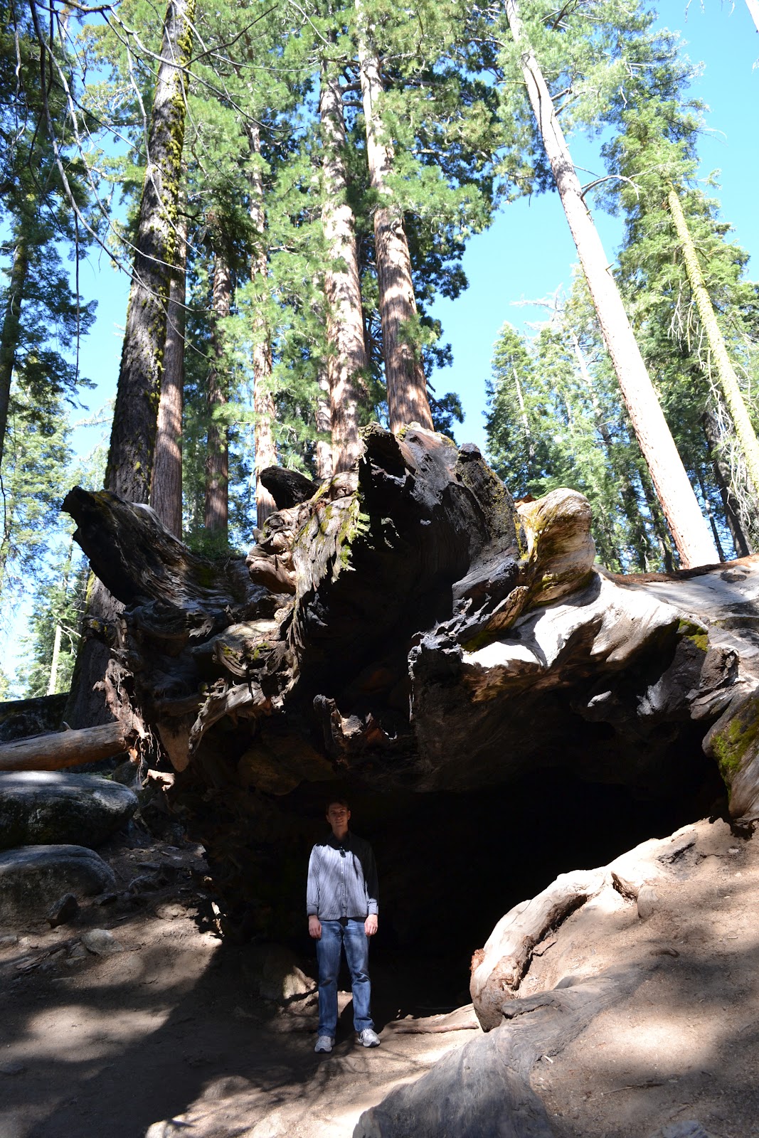
I found many interesting sequoia trees along the trail. We could touch or climb on some of them. There was one fallen tree that was hollow, so we could walk through to the other side. It was an amazing experience!
 |
| The big trees at the parking lot |
 |
| One of the giant trees |
 |
| The paved loop trail to the General Grant Tree |
 |
| The root/base of the fallen tree |
 |
| A hollow log |
 |
| Nathan and the Giant |
 |
| I wish I had a tree house here. |
 |
| Another fallen tree |
 |
| The parking area |
Panoramic Point
The
road to the Panoramic Point is a narrow, windy
road that is open in summer only. From the parking lot, we had to walk up
hill about 0.25 mile to the ridge. The view from there was stunning! We saw Hume Lake and the mountains very clearly on the day we
visited. The trail continues for about 4 miles along the ridge for stunning
vistas. Nathan and I decided that we wouldn't go all the way, so we just stopped
at the vista point.
Stony Creek Campground
Nathan and I stayed at
Stony Creek Campground for a couple of nights.It's located in Sequoia National Forest, and it's between Sequoia NP and Kings Canyon NP. The rate for tent camping is $20/night, and you can have a maximum of 6 people per campsite.
This campsite is also close to
Stony Creek Village, where you can get a shower, gasoline, and groceries. There is also a pizza place here if you get tired of camp food. The gasoline price here is about 10-15 cents/gallon more expensive than the gasoline outside of the park, which I think isn't that bad at all.
Nathan and I loved this campground so much. We stayed in campsite #14, which was very spacious and right next to the beautiful creek where people often go fishing. There was an elderly couple taking care of this campground, and they were very sweet and helpful and kept the bathroom clean at all times. The campground was very quiet at night, and we could see a lot of bright stars overhead in the dark sky. During the day we saw some deer visit some nearby campsites too!
 |
| Every campsite has a bear box and a picnic table. |
 |
| The creek behind our campsite |
 |
| Our tent under the big, tall trees |
 |
| The night sky at the campground |
 |
| There were a lot of fish in the creek behind our campsite, and people liked to come fishing here. |
Lodgepole Visitor Center
The next morning Nathan and I got up really early, and we left our campsite around 7:40 a.m. to go to
Lodgepole Visitor Center to buy a tour ticket to
Crystal Cave. The ticket is $13/person, and they only sell it here and at the Foothill Visitor Center. Nathan and I got the 11 a.m. tour tickets, so we had plenty of time to walk around the Giant Forest area.
Sherman Tree Trail
This popular paved trail is only 1 mile round-trip, but it can be challenging on the way back because you will walk uphill. On our visit, we had to park at the summer parking lot and walk down the beautiful trail through the
Giant Forest Grove. However, if the traffic in the park is heavy, you might have to park at Lodgepole Visitor Center and take a free shuttle bus to every major site of the park.
The General Sherman Tree is about 2,100 years old, and it is considered to be the largest living tree in the world because of its volume. You might see a tree that is taller or wider than this one, but the volume of the General Sherman Tree is the greatest. It is still growing...


 |
| The largest tree on earth |
Giant Forest Museum
This is a nice little museum located in the middle of the Giant Forest Grove. There is a big parking lot across the street from the museum, and there is a free shuttle from here to the Tunnel and Moro Rock. The museum has a small exhibit about the sequoias, comparing them to the redwood and other pine trees. We didn't really spend a lot of time here.


Big Trees Trail
This paved trail is 1.5 miles, and it circles around the meadow. Nathan and I walked on the trail from the Giant Forest Museum and later crossed the street to this trail. It's one of my favorite trails, but we didn't have much time to walk here because it was almost time for our cave tour at 11 a.m.
 |
| The trail starts from the Giant Forest Museum |
 |
| Walking across the street to the Big Trees Trail |
 |
| Can you see me in this picture? |
 |
| You have to look straight up to see the top of the tree. |
 |
| The Giants at the meadow |
 |
| Nathan at the feet of the Giants |
Crystal Cave
Nathan and I had to rush to our
Crystal Cave Tour. The road to the cave was very narrow and winding, but Nathan managed to get there safely. We got to the parking lot about 10 minutes before our tour started, but we didn't know that we were supposed to be at the parking lot 30 minutes before the tour started, and I didn't know that we had to hike down about 15 minutes to the cave entrance where our tour met. After going through the sanitizing of the shoes at the parking lot, we had to run down the strenuous 0.5 mile trail to the cave entrance. Luckily we got there 3 minutes early, so we were able to join the tour.
The Crystal Cave Tour is a 45-minute guided tour. We walked through the cave seeing the limestone formations. The tour guide said that the ceiling of the cave was under a river bank, and there were a lot of bacteria growing on the ceiling that can be useful for making medicine. The tour led us through about 3 rooms in the cave, and each room had a different geological feature. Overall , it was a very beautiful cave and a nice tour.
After the tour, Nathan and I walked up the steep trail back to the parking lot. It was a very beautiful trail. There are waterfalls right in front of the cave, and there were a lot of wild flowers in bloom.


Hospital Rock
Nathan and I drove to
Hospital Rock's picnic area for lunch. It was a long drive, and Hwy198 was under construction at the time, so we had to expect about a 20-minute traffic delay. There was an exhibit at the picnic area giving information about the Monache people who lived here until the 1870s. Nathan and I didn't walk on the Hospital Rock trail because we didn't know where it was. We just unintentionally drove to the Buckeye Flat Campground and got a snap shot of the creek and mountains by the campground.

Hume Lake
Hume Lake is located in the Sequoia National Forest. Nathan and I took the small, scenic road passing this lake to go to the Cedar Grove in Kings Canyon NP. There is a little village at the lake, and a ton of people were hanging around the lake, fishing, boating, kayaking, or swimming. You can also get gasoline here, but the price is a lot higher that the one at the Stony Creek Village.
Kings Canyon Scenic Byway and Cedar Grove
Kings Canyon National Park is a very rugged park compared to the Sequoia NP. There are a lot of campgrounds and back-country hiking trails. The driving on the scenic road was gorgeous. Kings Canyon looked so much like the canyon in Yosemite. There are many vista points along the way for a good shot of the canyon.
There were two waterfalls along the way. The first one is very close to the road and is called
Grizzly Falls.The second one is called
Roaring River Falls, and we had to walk about 3-5 minutes to get there. The Roaring River Falls had a much stronger flow of water than the Grizzly Falls, and it seemed dangerous to swim in the Grizzly Falls' pool.
 |
| The Kings Canyon |

 |
| The Kings Canyon Scenic Byway |
 |
| Grizzly Falls |
 |
| Grizzly Falls |
 |
| Nathan at the Grizzly Falls |
 |
| The Roaring River Falls |


Lost Grove
On our last day in the parks, Nathan and I stopped at
Lost Grove to see the living giant tree with a big hollow. Lost Grove is located right at the border between Sequoia National Forest and Sequoia National Park. It isn't far from our campsite. This grove has many giant sequoias, but it is pretty steep to walk up to the trees.


Moro Rock
Moro Rock is a large granite dome located in the Giant Forest Area. Nathan and I wanted to go to this place the day before, but we saw the road was closed, so we waited to go on our way back home the next day. The road to Moro Rock and the Crescent Meadow was closed for private vehicles from 9 a.m. to 4 p.m. on weekends, so we had to take the shuttle there.
To get to the top of Moro Rock, we had to climb the 0.25-mile trail with about 400 steep steps. The view from the top was gorgeous, but I wouldn't recommend it if you are scared of heights.
Tunnel Log
After hiking to the top of Moro Rock, Nathan and I took the shuttle back to the parking lot at the Giant Forest Museum. The shuttle drove pass the
Tunnel Log on the way to the Crescent Meadow. There isn't a stop at the Tunnel Log, and the driver didn't slow down for the tourists to get a good memorable picture of the log. I think it would be better to come here in your own vehicle if you can so that you can enjoy this site more. The forest around here is also very pretty to walk through.
On The Way Home...
After doing everything we could in the Sequoia and Kings Canyon National Parks, Nathan and I just headed home. On our way back, we decided to take a different way than we came into the park, by taking Hwy 198 past Three Rivers and Lake Kaweah. We stopped at
Lake Kaweah for our picnic lunch. Later we stopped at
Pyramid Lake for a break to go to the restroom. Both lakes have stunning views and nice exhibits.
 |
| A very nice visitor center with a small exhibit at Lake Kaweah |
 |
| A very nice picnic table at Lake Kaweah |
 |
| Houseboats floating at Lake Kaweah |
 |
| The view of Pyramid Lake from the Visitor Center |
 |
| The Visitor Center has a really big exhibit about the water system in California. |